
MontereyLovers Point
Lovers Point
Pacific Grove, Monterey Bay, California
Lovers Point · Right now
Good
Waves at this site, 13 s swell:
- Great under ~1.7 ft
- Good to ~2.9 ft
- Fair to ~4 ft
- Rough to ~6 ft
- Severe above ~6 ft
Partly sheltered from west swell. Some surge possible around the point.
High confidence
High confidence: Based on a live buoy reading 30 min ago.
Updated 24 min ago
Buoy reading: 4:00 PM (54 min ago) at buoy 46236. Measured offshore waves; the current rating starts from it.
Forecast issued: Wed, Oct 14, 1:26 PM PDT. NWS wind and air forecast for this spot; later hours also use the wave model run named under Advanced.
Page data: refreshed every 30 minutes; last refresh Wed, Oct 14, 4:30 PM PDT.
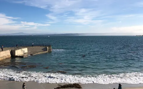
Right now
- Waves
- 1.7ft Estimate
- Swell
- 3ft WNW · 13 sec
- Wind
- 11kt Cross-shore
- Tide
- 3.6ft Falling · 0.8 ft above predicted
From the CDIP MOP nearshore wave model (Scripps Institution of Oceanography) at about 15 m depth off this site. An estimate, not a measurement at the beach.
All readings
- Swells: 3 ft, 13 s WNW · 3 ft, 7 s WNW · Wind 11 kt cross-shore
- Next low tide 8:15 PM (0.3 ft)
- Next high tide 3:37 AM (3.6 ft)
- Water temperature from the Monterey harbor tide station (NOAA 9413450); wind (including half the gust) and air from the NWS forecast for this hour.
Forecast limitations
The rating covers surge and entry conditions only.
- Visibility Plankton, runoff and water stirred up for days after big seas aren't in the rating. A "Vis likely poor" note only warns when a known cause is present; it never promises clear water.
- Depth On long-period days, surge on deeper reefs is stronger than at the entry.
- On the day Sets, kelp and currents vary; look at the water before you go in.
- Further out Accuracy drops the further out you look; days 6 and 7 are a rough guide.
Plan your dive
Today · Select a time
Day GoodAfter dark GoodWhy Good?
A modest long-period west swell is partly blocked by the Monterey Peninsula, so expect some surge around the point.
Swells: 3 ft, 13 s WNW · 3 ft, 7 s WNW · Wind 11 kt cross-shore
Rated by the most challenging conditions in the rest of today's daytime, to 8 PM. After dark (8 PM to midnight) is shown as conditions, not as a dive window.
High confidence: Based on a live buoy reading from the last hour.
This window has passed.
This window has passed.
Partly sheltered from west swell. Some surge possible around the point.
- Waves
- 1.7ft Estimate
- Swell
- 3ft WNW · 13 sec
- Wind
- 11kt Cross-shore
- Tide
- 2.7ft
From the CDIP MOP nearshore wave model (Scripps Institution of Oceanography) at about 15 m depth off this site. An estimate, not a measurement at the beach.
Roughest around 4:30 PM
High confidence
High confidence: Based on a live buoy reading 54 min ago.
Sunset 6:33 PMDark by 6:59 PMWaxing crescent, about 16% lit
Partly sheltered from northwest swell. Some surge possible around the point.
- Waves
- 1.7ft Estimate
- Swell
- 2.5ft WNW · 13 sec
- Wind
- 6kt Light
- Tide
- 0.3ft
From the CDIP MOP nearshore wave model (Scripps Institution of Oceanography) at about 15 m depth off this site. An estimate, not a measurement at the beach.
Low tide 8:15 PM (0.3 ft) · Roughest around 8 PM
High confidence
High confidence: This is a forecast about 4 hours ahead; recent forecasts have matched the buoy well.
Reduced visibility after dark; access rules still apply.
Sunset 6:33 PMDark by 6:59 PMWaxing crescent, about 16% lit
Thu, Oct 15 · Select a time
Day GoodAfter dark GoodWhy Good?
A modest northwest swell is partly blocked by the Monterey Peninsula, so expect some surge around the point.
Swells: 2 ft, 12 s WNW · 2 ft, 14 s SSW · 2 ft, 6 s NW · Wind 9 kt onshore
Rated by the most challenging conditions from 7 AM to 8 PM. After dark (8 PM to midnight) is shown as conditions, not as a dive window.
Medium confidence because this forecast is about 15 hours ahead, though recent forecasts have matched the buoy well.
Partly sheltered from northwest swell. Some surge possible around the point.
- Waves
- 1.5ft Estimate
- Swell
- 2.3ft WNW · 12 sec
- Wind
- 9kt Onshore
- Tide
- 3.3ft
From the CDIP MOP nearshore wave model (Scripps Institution of Oceanography) at about 15 m depth off this site. An estimate, not a measurement at the beach.
Roughest around 7 AM
Medium confidence
Medium confidence because this forecast is about 15 hours ahead, though recent forecasts have matched the buoy well.
Partly sheltered from northwest swell. Some surge possible around the point.
- Waves
- 1.5ft Estimate
- Swell
- 2.3ft WNW · 12 sec
- Wind
- 10kt Cross-shore
- Tide
- 4.9ft
From the CDIP MOP nearshore wave model (Scripps Institution of Oceanography) at about 15 m depth off this site. An estimate, not a measurement at the beach.
High tide 1:10 PM (5.1 ft) · Roughest around 12 PM
Medium confidence
Medium confidence because this forecast is about 20 hours ahead, though recent forecasts have matched the buoy well.
Partly sheltered from northwest swell. Some surge possible around the point.
- Waves
- 1.5ft Estimate
- Swell
- 2.3ft WNW · 12 sec
- Wind
- 9kt Cross-offshore
- Tide
- 2ft
From the CDIP MOP nearshore wave model (Scripps Institution of Oceanography) at about 15 m depth off this site. An estimate, not a measurement at the beach.
Roughest around 6 PM
Low confidence
Low confidence because the wave model is in its first week of calibration here; this forecast is about 26 hours ahead, though recent forecasts have matched the buoy well.
Sunset 6:31 PMDark by 6:57 PMWaxing crescent, about 24% lit
Partly sheltered from northwest swell. Some surge possible around the point.
- Waves
- 1.5ft Estimate
- Swell
- 2.3ft WNW · 12 sec
- Wind
- 6kt Onshore
- Tide
- 0.6ft
From the CDIP MOP nearshore wave model (Scripps Institution of Oceanography) at about 15 m depth off this site. An estimate, not a measurement at the beach.
Low tide 9:11 PM (0.4 ft) · Roughest around 8 PM
Low confidence
Low confidence because the wave model is in its first week of calibration here; this forecast is about 28 hours ahead, though recent forecasts have matched the buoy well.
Reduced visibility after dark; access rules still apply.
Sunset 6:31 PMDark by 6:57 PMWaxing crescent, about 24% lit
Fri, Oct 16 · Select a time
Day GoodAfter dark GoodWhy Good?
A modest northwest swell is partly blocked by Point Pinos, so expect some surge around the point.
Swells: 3 ft, 12 s WNW · 2 ft, 14 s SSW · Wind 10 kt onshore
Rated by the most challenging conditions from 7 AM to 8 PM. After dark (8 PM to midnight) is shown as conditions, not as a dive window.
Low confidence because the wave model is in its first week of calibration here; this forecast is about 39 hours ahead, though recent forecasts have matched the buoy well.
Partly sheltered from northwest swell. Some surge possible around the point.
- Waves
- 1.4ft Estimate
- Swell
- 2.6ft WNW · 12 sec
- Wind
- 10kt Onshore
- Tide
- 3.5ft
From the CDIP MOP nearshore wave model (Scripps Institution of Oceanography) at about 15 m depth off this site. An estimate, not a measurement at the beach.
Low tide 7:37 AM (3.5 ft) · Roughest around 7 AM
Low confidence
Low confidence because the wave model is in its first week of calibration here; this forecast is about 39 hours ahead, though recent forecasts have matched the buoy well.
Partly sheltered from northwest swell. Some surge possible around the point.
- Waves
- 1.3ft Estimate
- Swell
- 2.4ft WNW · 12 sec
- Wind
- 7kt Onshore
- Tide
- 4.7ft
From the CDIP MOP nearshore wave model (Scripps Institution of Oceanography) at about 15 m depth off this site. An estimate, not a measurement at the beach.
High tide 1:58 PM (4.8 ft) · Roughest around 1 PM
Low confidence
Low confidence because the wave model is in its first week of calibration here; this forecast is about 45 hours ahead, though recent forecasts have matched the buoy well.
Partly sheltered from northwest swell. Some surge possible around the point.
- Waves
- 1.2ft Estimate
- Swell
- 2.4ft WNW · 12 sec
- Wind
- 8kt Cross-offshore
- Tide
- 4.2ft
From the CDIP MOP nearshore wave model (Scripps Institution of Oceanography) at about 15 m depth off this site. An estimate, not a measurement at the beach.
Roughest around 4 PM
Low confidence
Low confidence because the wave model is in its first week of calibration here; this forecast is about 48 hours ahead, though recent forecasts have matched the buoy well. Capped at Good because confidence is Low.
Sunset 6:30 PMDark by 6:56 PMFirst quarter, about 34% lit
Partly sheltered from south swell. Several factors near their limits at once.
- Waves
- 1.2ft Estimate
- Swell
- 1.9ft SSW · 14 sec
- Wind
- 5kt Light
- Tide
- 1.3ft
From the CDIP MOP nearshore wave model (Scripps Institution of Oceanography) at about 15 m depth off this site. An estimate, not a measurement at the beach.
Low tide 10:14 PM (0.6 ft) · Roughest around 8 PM
Low confidence
Low confidence because it is about 52 hours out, though recent forecasts have matched the buoy well.
Reduced visibility after dark; access rules still apply.
Sunset 6:30 PMDark by 6:56 PMFirst quarter, about 34% lit
Sat, Oct 17 · Select a time
Day GoodAfter dark GoodWhy Good?
A modest short-period northwest swell is partly blocked by the Monterey Peninsula, so expect some surge around the point.
Swells: 3 ft, 7 s WNW · 2 ft, 12 s WNW · 2 ft, 17 s SSW · Wind 11 kt cross-shore
Rated by the most challenging conditions from 7 AM to 8 PM. After dark (8 PM to midnight) is shown as conditions, not as a dive window.
Low confidence because it is about 75 hours out, though recent forecasts have matched the buoy well.
Partly sheltered from northwest swell. Some surge possible around the point.
- Waves
- 1.4ft Estimate
- Swell
- 1.9ft WNW · 6 sec
- Wind
- 8kt Onshore
- Tide
- 3.7ft
From the CDIP MOP nearshore wave model (Scripps Institution of Oceanography) at about 15 m depth off this site. An estimate, not a measurement at the beach.
Low tide 9:03 AM (3.6 ft) · Roughest around 7 AM
Low confidence
Low confidence because it is about 63 hours out, though recent forecasts have matched the buoy well.
Partly sheltered from northwest swell. Some surge possible around the point.
- Waves
- 1.6ft Estimate
- Swell
- 2.5ft WNW · 7 sec
- Wind
- 12kt Cross-shore
- Tide
- 4.4ft
From the CDIP MOP nearshore wave model (Scripps Institution of Oceanography) at about 15 m depth off this site. An estimate, not a measurement at the beach.
High tide 3:04 PM (4.5 ft) · Roughest around 2 PM
Low confidence
Low confidence because it is about 70 hours out, though recent forecasts have matched the buoy well.
Partly sheltered from northwest swell. Some surge possible around the point.
- Waves
- 1.9ft Estimate
- Swell
- 3.2ft WNW · 7 sec
- Wind
- 11kt Cross-shore
- Tide
- 2.7ft
From the CDIP MOP nearshore wave model (Scripps Institution of Oceanography) at about 15 m depth off this site. An estimate, not a measurement at the beach.
Roughest around 7 PM
Low confidence
Low confidence because it is about 75 hours out, though recent forecasts have matched the buoy well.
Sunset 6:29 PMDark by 6:55 PMFirst quarter, about 44% lit
Partly sheltered from northwest swell. Some surge possible around the point.
- Waves
- 2.2ft Estimate
- Swell
- 3.3ft WNW · 7 sec
- Wind
- 8kt Cross-shore
- Tide
- 0.6ft
From the CDIP MOP nearshore wave model (Scripps Institution of Oceanography) at about 15 m depth off this site. An estimate, not a measurement at the beach.
Low tide 11:18 PM (0.6 ft) · Roughest around 11 PM
Low confidence
Low confidence because it is about 79 hours out, though recent forecasts have matched the buoy well.
Reduced visibility after dark; access rules still apply.
Sunset 6:29 PMDark by 6:55 PMFirst quarter, about 44% lit
Sun, Oct 18 · Select a time
Day FairAfter dark FairWhy Fair?
A moderate northwest swell is partly blocked by the Monterey Peninsula, so expect noticeable surge around the point.
Swells: 6 ft, 12 s WNW · 2 ft, 16 s SSW · 1 ft, 12 s SSW · Wind 17 kt cross-shore
Rated by the most challenging conditions from 7 AM to 8 PM. After dark (8 PM to midnight) is shown as conditions, not as a dive window.
Low confidence because it is about 94 hours out, though recent forecasts have matched the buoy well.
Partly sheltered from northwest swell. Noticeable surge around the point.
- Waves
- 2.6ft Estimate
- Swell
- 4.1ft WNW · 8 sec
- Wind
- 8kt Cross-shore
- Tide
- 3.7ft
From the CDIP MOP nearshore wave model (Scripps Institution of Oceanography) at about 15 m depth off this site. An estimate, not a measurement at the beach.
High tide 7:17 AM (3.8 ft) · Low tide 11:05 AM (3.5 ft) · Roughest around 9 AM
Low confidence
Low confidence because it is about 89 hours out, though recent forecasts have matched the buoy well.
Partly sheltered from northwest swell. Noticeable surge around the point.
- Waves
- 2.7ft Estimate
- Swell
- 6.1ft WNW · 12 sec
- Wind
- 17kt Cross-shore
- Tide
- 4ft
From the CDIP MOP nearshore wave model (Scripps Institution of Oceanography) at about 15 m depth off this site. An estimate, not a measurement at the beach.
Roughest around 2 PM
Low confidence
Low confidence because it is about 94 hours out, though recent forecasts have matched the buoy well.
Partly sheltered from northwest swell. Noticeable surge around the point.
- Waves
- 2.7ft Estimate
- Swell
- 4.9ft WNW · 8 sec
- Wind
- 17kt Cross-shore
- Tide
- 4.4ft
From the CDIP MOP nearshore wave model (Scripps Institution of Oceanography) at about 15 m depth off this site. An estimate, not a measurement at the beach.
High tide 4:24 PM (4.4 ft) · Roughest around 4 PM
Low confidence
Low confidence because it is about 96 hours out, though recent forecasts have matched the buoy well.
Sunset 6:27 PMDark by 6:53 PMFirst quarter, about 55% lit
Partly sheltered from northwest swell. Noticeable surge around the point.
- Waves
- 2.7ft Estimate
- Swell
- 6ft WNW · 12 sec
- Wind
- 19kt Cross-shore
- Tide
- 2ft
From the CDIP MOP nearshore wave model (Scripps Institution of Oceanography) at about 15 m depth off this site. An estimate, not a measurement at the beach.
Roughest around 9 PM
Low confidence
Low confidence because it is about 101 hours out, though recent forecasts have matched the buoy well.
Reduced visibility after dark; access rules still apply.
Sunset 6:27 PMDark by 6:53 PMFirst quarter, about 55% lit
Mon, Oct 19 · Select a time
Day FairAfter dark FairWhy Fair?
A moderate northwest swell is partly blocked by the Monterey Peninsula, so expect noticeable surge around the point.
Swells: 5 ft, 12 s WNW · 2 ft, 15 s SSW · 0.9 ft, 18 s S · Wind 16 kt cross-shore
Rated by the most challenging conditions from 7 AM to 8 PM. After dark (8 PM to midnight) is shown as conditions, not as a dive window.
Low confidence because it is about 112 hours out, though recent forecasts have matched the buoy well.
Partly sheltered from northwest swell. Noticeable surge around the point.
- Waves
- 2.4ft Estimate
- Swell
- 5.2ft WNW · 12 sec
- Wind
- 16kt Cross-shore
- Tide
- 4ft
From the CDIP MOP nearshore wave model (Scripps Institution of Oceanography) at about 15 m depth off this site. An estimate, not a measurement at the beach.
High tide 7:44 AM (4 ft) · Roughest around 8 AM
Low confidence
Low confidence because it is about 112 hours out, though recent forecasts have matched the buoy well.
Partly sheltered from northwest swell. Noticeable surge around the point.
- Waves
- 2.3ft Estimate
- Swell
- 4.9ft WNW · 12 sec
- Wind
- 19kt Cross-shore
- Tide
- 3.2ft
From the CDIP MOP nearshore wave model (Scripps Institution of Oceanography) at about 15 m depth off this site. An estimate, not a measurement at the beach.
Low tide 12:28 PM (3.2 ft) · Roughest around 12 PM
Low confidence
Low confidence because it is about 116 hours out, though recent forecasts have matched the buoy well.
Partly sheltered from northwest swell. Noticeable surge around the point.
- Waves
- 2.3ft Estimate
- Swell
- 5.9ft WNW · 12 sec
- Wind
- 23kt Cross-shore
- Tide
- 4ft
From the CDIP MOP nearshore wave model (Scripps Institution of Oceanography) at about 15 m depth off this site. An estimate, not a measurement at the beach.
High tide 5:41 PM (4.3 ft) · Roughest around 4 PM
Low confidence
Low confidence because it is about 120 hours out, though recent forecasts have matched the buoy well.
Sunset 6:26 PMDark by 6:52 PMFirst quarter, about 65% lit
27 kt cross-shore wind roughs up the surface. Partly sheltered from northwest swell.
- Waves
- 2.2ft Estimate
- Swell
- 4.9ft WNW · 12 sec
- Wind
- 27kt Cross-shore
- Tide
- 2.7ft
From the CDIP MOP nearshore wave model (Scripps Institution of Oceanography) at about 15 m depth off this site. An estimate, not a measurement at the beach.
Roughest around 9 PM
Low confidence
Low confidence because it is about 125 hours out, though recent forecasts have matched the buoy well.
Reduced visibility after dark; access rules still apply.
Sunset 6:26 PMDark by 6:52 PMFirst quarter, about 65% lit
Tue, Oct 20 · Select a time
Day RoughAfter dark RoughNo wind forecast yet for part of this day; those hours cover swell and tide only.
Why Rough?
A moderate northwest swell is partly blocked by the Monterey Peninsula, so expect strong surge around the point.
Swells: 7 ft, 13 s WNW · 2 ft, 15 s SSW
Rated by the most challenging conditions from 7 AM to 8 PM. After dark (8 PM to midnight) is shown as conditions, not as a dive window.
Low confidence because it is about 147 hours out, though recent forecasts have matched the buoy well.
Partly sheltered from northwest swell. Small waves, but long-period surge builds around the point.
- Waves
- 2.6ft Estimate
- Swell
- 2.9ft NW · 14 sec
- Wind
- –
- Tide
- 3.3ft
From the CDIP MOP nearshore wave model (Scripps Institution of Oceanography) at about 15 m depth off this site. An estimate, not a measurement at the beach.
High tide 8:05 AM (4.2 ft) · Roughest around 11 AM
Low confidence
Low confidence because it is about 139 hours out, though recent forecasts have matched the buoy well.
Partly sheltered from northwest swell. Small waves, but long-period surge builds around the point.
- Waves
- 3.2ft Estimate
- Swell
- 5.8ft WNW · 13 sec
- Wind
- –
- Tide
- 3ft
Beyond the CDIP MOP forecast: the offshore wave forecast scaled the way MOP scales it at this site. An estimate, not a measurement at the beach.
Low tide 1:23 PM (2.7 ft) · Roughest around 3 PM
Low confidence
Low confidence because it is about 143 hours out, though recent forecasts have matched the buoy well.
Partly sheltered from northwest swell. Strong surge expected around the point.
- Waves
- 3.6ft Estimate
- Swell
- 6.6ft WNW · 13 sec
- Wind
- –
- Tide
- 4.3ft
Beyond the CDIP MOP forecast: the offshore wave forecast scaled the way MOP scales it at this site. An estimate, not a measurement at the beach.
High tide 6:47 PM (4.3 ft) · Roughest around 7 PM
Low confidence
Low confidence because it is about 147 hours out, though recent forecasts have matched the buoy well.
Sunset 6:25 PMDark by 6:51 PMWaxing gibbous, about 75% lit
Partly sheltered from northwest swell. Strong surge expected around the point.
- Waves
- 3.6ft Estimate
- Swell
- 6.6ft WNW · 13 sec
- Wind
- –
- Tide
- 4ft
Beyond the CDIP MOP forecast: the offshore wave forecast scaled the way MOP scales it at this site. An estimate, not a measurement at the beach.
Roughest around 8 PM
Low confidence
Low confidence because it is about 148 hours out, though recent forecasts have matched the buoy well.
Reduced visibility after dark; access rules still apply.
Sunset 6:25 PMDark by 6:51 PMWaxing gibbous, about 75% lit
Hourly outlook 7 days · tap any hourhold and drag the chart
After darkOvernight
Tap any hour for details.
Entry & parking
Shore entry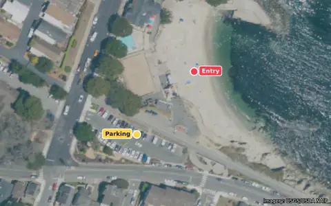
Entry: The small sandy beach beside Lovers Point Park, inside the cove.
Parking: Lot and street parking by the park on Ocean View Boulevard.
Access: No permit needed. A popular swimming and kayaking beach in summer.
Directions to the entryDirections to parking
Entry hazards
Rocks and surge around the point itself. Kayakers and swimmers use the cove on summer days.
Live cams & observations
Recent offshore observations · Buoy 46236
- Wave height
- 4.3ft
- Period
- 13s
- Water
- 64°F
Live cams
Randall Spangler's conditions guide · Monterey County Dive Reports
About this dive site
The diving
Shallow cove with kelp and granite reef.
Conditions & exposure
The point blocks west and northwest swell at the beach; outside the point, direct swell comes only from about 311 to 325 degrees. Long-period south swell wraps in here (it is a known south-swell surf spot).
Hazards & considerations
Beginner friendly inside the cove on calm days.
Advanced forecast & data
This site's forecast combines offshore wave data, predicted ocean conditions, and Lovers Point's exposure to incoming swell.
Show the data and method
Buoy 46236, Monterey Canyon Outer: last 48 hours
Swell trains now (buoy 46236 spectrum, 3:00 PM): 3 ft at 14 s from 284° (WNW) · wind waves 3 ft at 7 s. The rating still uses the buoy's single swell and wind-wave split; the full spectrum is being compared against it.
Forecast vs. buoy 46236
The raw GFS-Wave forecast is running about 0.7 ft low at buoy 46236 today (last 24 hours). The SurgeCast forecast corrects for it.
Wave height
Peak period
Buoy (measured)SurgeCast forecast (corrected)GFS-Wave (raw)Last 3 days and next 2
For comparison, the NWS marine grid ran 0.1 ft low over the same 24 hours. Low means the forecast was smaller than what the buoy measured; high means bigger.
Download the forecast-vs-buoy data (CSV) · NOAA's own spot-check (a handful of NOAA forecasts against this buoy; heights in meters; posted Tue, Oct 13)
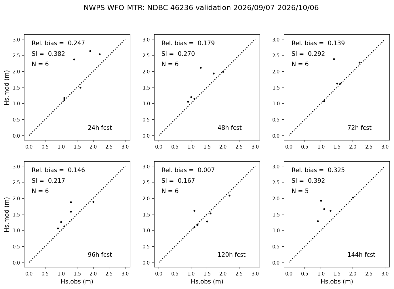
Forecast check: The wave model is scaled by 1.12 at the Monterey Canyon Outer buoy (a starting estimate until 7 days of readings are logged). After that, over the last 36 hours the forecast has matched the Monterey Canyon Outer buoy well (69 readings compared).
Validation: Validation in progress: 69 forecast-and-buoy pairs so far since Tue, Oct 13. Accuracy numbers appear here once there are 100 pairs over at least 3 days.
Buoy split now: swell 3 ft at 13.3 s from the WNW, 40% reaches this site; wind waves 3 ft at 6.7 s from the WNW, 40% reaches this site.
View official NOAA forecast chart
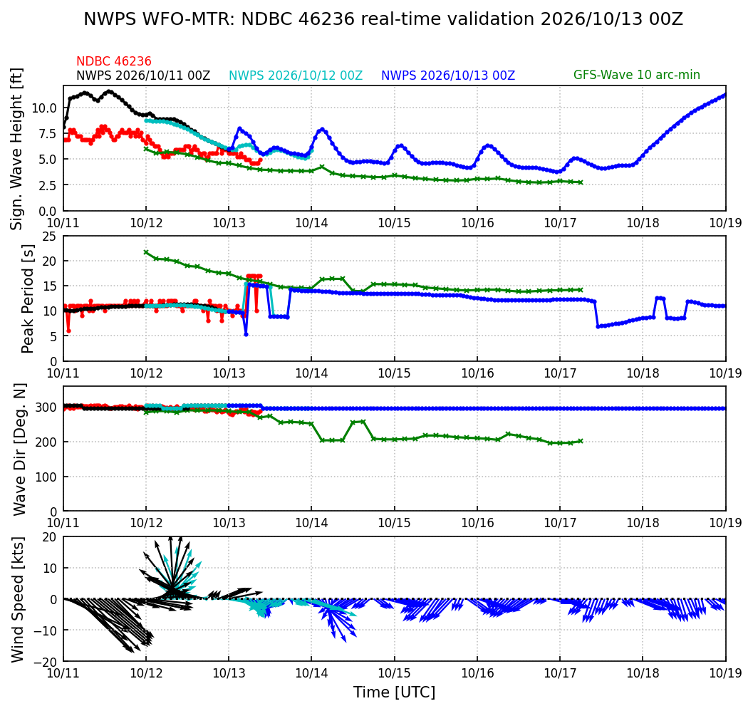
The chart did not load.
Red dots: the buoy. Blue: the latest NWPS forecast; black and light blue: earlier runs. Green: the global GFS-Wave model. Times are UTC (subtract 7 hours for Pacific daylight time). View the full forecast at NOAA
Forecast models
Waves from the NOAA GFS-Wave (WAVEWATCH III) model, run 18Z Wed, Oct 14 at buoy 46236, corrected against what that buoy has measured (systematic factor 1.12, seeded until 7 days of data are logged). The rating uses each hour's waves, wind and tide. Wind and air temperature come from the NWS forecast for the water off Lovers Point, issued Wed, Oct 14, 1:26 PM PDT.
NWS marine forecast: Monterey Bay
Tonight: W wind around 5 kt, veering to NE late this evening and early morning, then becoming NE 5 to 10 kt late. Seas 3 to 4 ft. Wave Detail: NW 3 ft at 8 seconds and SW 2 ft at 15 seconds.
Thu: NE wind 5 to 10 kt, backing to NW in the afternoon. Seas around 3 ft. Wave Detail: W 3 ft at 7 seconds and SW 2 ft at 15 seconds.
Thu Night: NE wind 5 to 10 kt. Seas around 3 ft. Wave Detail: NW 2 ft at 7 seconds and SW 2 ft at 15 seconds.
Fri: NE wind 5 to 10 kt, becoming NW in the afternoon. Seas around 3 ft. Wave Detail: W 2 ft at 11 seconds.
Issued Wed, Oct 14, 2:38 PM PDT
View official NOAA swell-systems chart
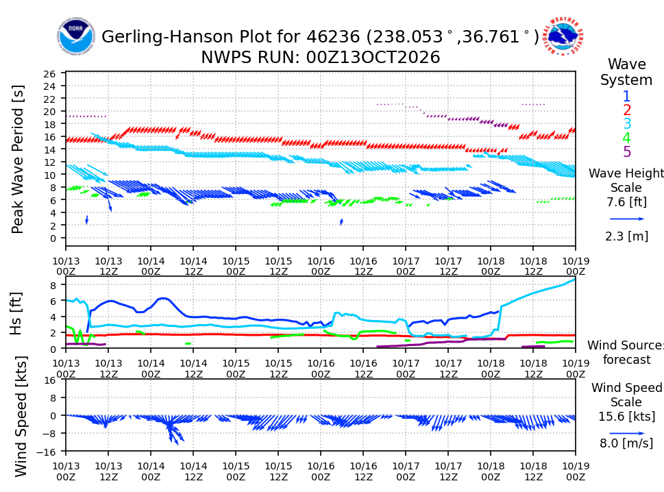
The chart did not load.
Each color is one swell system; arrow length shows its size. A band at 15 s and up means long-period swell and surge. Times are UTC. View the full forecast at NOAA
Rating logic
- Surge
- The rating turns each swell into a "surge index" in feet: the height that reaches this site, weighted up for longer periods because long swell moves the water harder near the bottom. Here the index moves from Great to Good at 1.4, Fair at 2.5, Rough at 3.7 and Severe at 5.5 ft. Right now it is 1.7 ft.
- Direction
- The point blocks west and northwest swell at the beach; outside the point, direct swell comes only from about 311 to 325 degrees. Long-period south swell wraps in here (it is a known south-swell surf spot).
- Wind
- Onshore wind here blows from the NE. Onshore wind over about 10 kt chops up entries and surface swims; a strong offshore wind (over 15 kt) pushes surface swimmers out. Gusts count for half.
- Tide
- Heights at the Monterey tide station, in feet above mean lower low water. The entry is easiest between -0.5 and 6 ft; tide only nudges the rating.
- Trend and confidence
- The trend compares the last 9 hours at the buoy with the next 12 hours of forecast; a building long-period swell can push a borderline day one step worse. Confidence is High for a fresh buoy reading or a forecast for the next 12 hours, and drops with lead time, a backup buoy, or a forecast that has been missing the buoy.
- Limits
- A model, not a guarantee. Back-tested on 137 dated diver reports, it matched the reported level 72% of the time and was within one level 96% of the time (tuned on those same reports, so expect a little less). Always look before you go in.
Sources
- NDBC buoy 46240 (Cabrillo Point) Off Lovers Point. Silent since 2026-04-30; it is used again automatically if it returns.
- NDBC buoy 46236 (Monterey Canyon Outer) At the mouth of the bay; it usually reads 2 to 3 ft higher than the beaches, which the rating accounts for.
- NDBC buoy 46239 (Point Sur)
- CDIP station 158 (buoy 46240)
- CDIP station 156 (buoy 46236)
- NWPS viewer, Monterey office
- NWS point forecast
- NOAA tide predictions, Monterey
- Photo and font credits